Sope Creek, Cobb County, GA
Sope Creek is part of the Cochran Shoals Unit of the Chattahoochee River National Recreation Area in metropolitan Atlanta, GA. This unit is located near some of the nicest and most expensive homes in eastern Cobb County, but as you utilize the various trails in the park, sometimes the only thing that reminds you that you are in the middle of a city is the number of people that you encounter (well, another reminder might be the parking fees - plan on spending about $3 for the day). Parking is tight, and there are an abundance of "No Parking" signs along all of the nearby roads. Suggestion: take these signs seriously, especially along Columns Drive!

My daughters playing in Sope Creek. On this day, we started at the Sope Creek parking area off of Paper Mill Road and walked about a 1/2 mile along the trail to the creek and the paper mill ruins.

Sope Creek just above the Paper Mill Road bridge.

Sope Creek just below the Paper Mill Road bridge. The mill ruins are along this portion of the creek just out of the picture on the left, and further downstream on the opposite bank.

The stone ruins of the Marietta Paper Mill, burned to the ground by Sherman's troops in July, 1864.

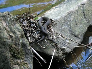
If you hike along the creek, keep an eye out, but it might not be what you think...
All pictures in this post were taken with a 2.0 megapixel Canon Powershot A60 on May 23rd, 2004.

My daughters playing in Sope Creek. On this day, we started at the Sope Creek parking area off of Paper Mill Road and walked about a 1/2 mile along the trail to the creek and the paper mill ruins.

Sope Creek just above the Paper Mill Road bridge.

Sope Creek just below the Paper Mill Road bridge. The mill ruins are along this portion of the creek just out of the picture on the left, and further downstream on the opposite bank.

The stone ruins of the Marietta Paper Mill, burned to the ground by Sherman's troops in July, 1864.

If you hike along the creek, keep an eye out, but it might not be what you think...
All pictures in this post were taken with a 2.0 megapixel Canon Powershot A60 on May 23rd, 2004.
0 Comments:
Post a Comment
<< Home